Sunday 5/8

Tsähkkok
| Horizontal distance: | 14 km |
| Vertical distance: | +700 m, -700 m |
| Time: | 5 h 25 min |
| Lunch break: | 45 min |
| Dinner: | – |
| Night accommodation: | – |
| Stage classification: | Hard |
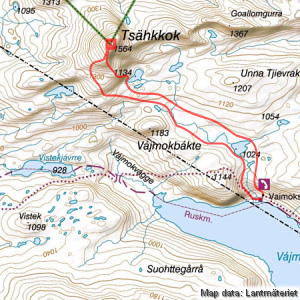
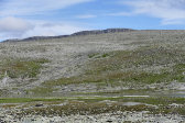
I ascended the slope on the trail and then continued straight northwards when it turned west, following the water upstream. The ground was mostly grassy at first, but there were some areas with the local type of light, flat rocks and/or dirt and moss. As I passed close by lake 1024 there were some insects in the air, but not of the biting kind. The following area was marked as fens on the map, but in actual fact it was an elongated body of water with tall grass and white cottongrass growing along the sides and in small islets, which made for very nice views, especially towards Tsähkkok which rose as a bastion straight ahead.
Walking was easy for the most part, and after crossing an area of smaller stones I came to a confluence of two arms of the stream, between which was a green "island". I proceeded north of the next tarn, which was marked as such on the map, and now the ground grew grassier again. As I neared the saddle point north of peak 1183 (the highest point of Vájmokbákte) the lands to the west opened up in a very welcoming way, the rocks giving way to green stretches down towards the turquoise Bieskehávrre in the distance, with the twin peaks of Nuortta Sávllo behind. This made me want to take this route on a camping trip some time, but for now I just imbibed the colorful scene.
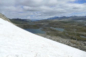
I continued up onto a grassy rise and then climbed up the next much steeper slope, partly on loose gravel, keeping more and more to the west. The peaks of Sulidälbmá were just emerging from their morning cloud, but further off to the west a haze was gathering. Closer at hand there was a lovely lake-filled hollow below me, which made for another great scene with more of the larger Bieskehávrre further off. I went on up on my western heading, slowly curving around towards the southern pre-summit, and the ground was good all the way. I covered the last bit to the actual summit from the southwest, coming to the top cairn around 12:15.
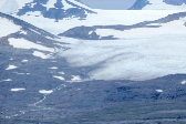
Rain was just passing on the other side of Nuortta Sávllo as well as further off to the south, and in Norway things seemed cloudy. There were some veils on the Swedish side, but no rain nearby, and there was only a light wind blowing. As expected, the views from Tsähkkok were spectacular, with all higher objects being sufficiently far away not to block much, and the gently undulating terrain of Badjelánnda made for very far-reaching sights. Just as at Juovvabuollda my phone had ample reception but no service, so no contact with the outside world now either. Having had lunch against the cairn I walked around the flat summit for a bit, photographing all around, while more clouds lowered themselves around Nuortta Sávllo and, after a while, Sulidälbmá as well.
When I finally left there was more wind, but I walked without the wind jacket just the same. I traced the eastern edge downwards, reaching the pre-summit in short fashion, and got it into my head to attempt a direct route from there down the steep southern side. This was possible by zigzagging between various cliffs, bluffs, outcrops and taluses – but only just, and it involved a great deal of careful movement, often requiring all four limbs. A more level section of grass followed, but then another precipitous slope took by and it was back to cautious circumventing navigation. Not for the faint of heart, this!
I came out onto a steeply slanting snowfield, which had obviously served as a reindeer toilet recently, but the surface was soft enough that I could walk down it slowly without fear of slipping. On the other side, however, an actual precipice took by, and I could go no further. Instead I turned due east where a narrow – sometimes very narrow – ledge extended downwards at a shallow angle. After a while I could wind my way down through and across grassy gulleys to lake 1134, where I had to backtrack a bit to get around its western bay. After that I was on friendly ground once more, and I could walk unhindered.
This I did further to the east than when I had come up, aiming more or less straight for Stájggá. It felt good to stretch out my stride, and now the sky was almost completely clear again, so walking was a joy. There were a few small rock fields, but it was not until I reached lake 1024 that it actually got stony again, and once I was past both that and the following smaller tarn grasslands took by once more. I went straight down the slope, keeping to the east this time when I reached the rock field that blocked the way, and came down directly to the warden's cottage around 15:15.
« Return to Vaimok report


